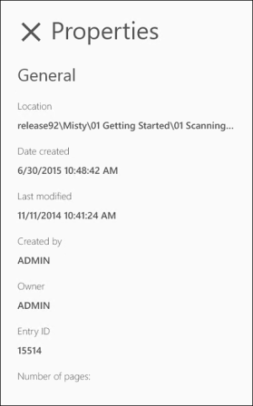
Document Properties
A document's properties provide valuable information about the document.
To access a document's properties,  in the app bar at the bottom to expand it, and
  in the app bar at the bottom

Geotag
If a document is created from a photo taken on the mobile device and if the geotag option is turned on during Mobile configuration, the Geotag property provides the GPS coordinates for where the document was taken. If the document is composed of multiple photos taken in different locations, the coordinates for the first photo in the document will be recorded. Press the Open in map application link to plot the photo's location on a map. Depending on your device's settings and applications, you may be prompted to choose a map application first.
General Properties
- Location: The location of the document in the repository.
- Date created: The date and time the document was added to the repository.
- Last modified: The date and time the document was last changed.
- Created by: The account name of the person who added the document to the repository.
- Owner: The document's owner has special security rights to the document. Usually, the person who creates the entry is its owner.
- Entry ID: The unique identifying number assigned to the document.
- Number of pages: How many pages are in the document.
- Indexed: Whether the document has been indexed or not. Documents must be indexed for their text to be searchable.
- Volume: The volume the document is stored in. You can configure the volume new documents are stored in with the Location and volume option, which is available when uploading a new document.
|
This documentation is specific to version 9.3. You can find the most up-to-date help files for the latest version at Current Online Laserfiche Product Help Files. For further help or feedback, please see the Laserfiche Support Site. |
© 2015 Laserfiche. All Rights Reserved. |